
What is a Natural Asset Inventory and Why Should I Care?
- kc dyer

- Feb 20
- 3 min read
Climate Action Committee member John Robb breaks it down

Editor's note: At the February 17 meeting, Council approved a recommendation from the Climate Action Committee to complete a Natural Asset Inventory, a concept discussed at the January 27 Committee of the Whole meeting. CAC member John Robb breaks down the details of all such an inventory entails here.
Story by John Robb
Lions Bay has provincial Local Government Climate Action Program (LGCAP) funding in reserve that needs to be spent by 2027.
The Climate Action Committee (CAC) has recently made a couple of proposals to Council on how to spend these funds in a manner that will provide the most value to the community.
At their meeting on February 17, Council unanimously approved a recommendation to pursue one of these, the development of a Natural Asset Inventory (NAI).
Ok, so what is a Natural Asset Inventory?
Natural assets are the elements of the natural environment in which we live that provide ongoing benefits to us, much like ‘produced’ assets such as infrastructure. They include both the stock of natural resources (like forests, rivers, soil, minerals) and whole ecosystems (like coastal shorelines). These natural assets are complementary to the human-made infrastructure: for example, we create dykes to stop flooding, but a complementary natural asset are eel grass beds, which are very effective at lessening potential damage by reducing wave height up to 40%.
All assets can degrade or appreciate to a greater or less extent depending on external pressures and their management – for natural assets, their ‘performance’ is tied to ecological health rather than purely mechanical conditions. Given that our natural assets in Lions Bay support critical services such as drinking water supply, flood and erosion control, fire protection, air purification and recreation, there are economic and risk implications to not managing them accordingly.
An NAI answers three basic questions: how much, of what, is where? It systematically identifies and maps features such as forests, wetlands, streams, shorelines, soils, aquifers, and parks, usually in a GIS system. For each asset, it documents its condition, function, and the services it provides, like stormwater management, water supply, cooling, recreation, and carbon storage.
Crucially, an NAI can link each natural asset to specific municipal services and risks. Once this is documented, an NAI provides a baseline, providing information that will inform what assets protect us – “resilience”; and those that could be enhanced to proactively protect the community – “mitigation”.
This sounds like an academic exercise…
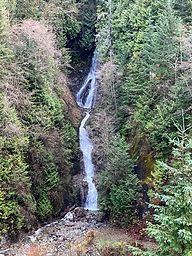
Lions Bay’s forests on steep mountain slopes store carbon, stabilize soil, reduce erosion, and provide the backdrop for our daily lives. Our watershed supplies drinking water, moves sediment safely from mountains to sea, and shapes flood and debris‑flow risks that have always influenced land use and hazard mapping in Howe Sound. Our shoreline provides habitat, recreation, and endless photographs; while at the same time buffering wave energy and supporting a recovering marine ecosystem that helps keep the water clean. Ultimately, the heart of the matter is that we live on the side of a mountain in a fjord, primed to suffer the consequences of the climate-fuelled change in weather patterns and sea-level rises that are already with us.
Our natural assets can be intentionally managed alongside infrastructure to protect us from these climate impacts. This is not theoretical – many communities are already applying their knowledge of their natural assets into practical projects.
Gibsons formally manages its aquifer, creeks, ponds, and foreshore as infrastructure, instead of relying on new stormwater ponds with engineered works that would cost millions of dollars. Surrey is piloting a “living dyke” for coastal resilience, and places like Grand Forks and Charlottetown now put natural assets at the centre of their flood and climate plans.
So what is the goal of the NAI project. . . .?
Lions Bay’s NAI will identify, map, and quantify these natural assets and systems and the services they provide in a way that eventually will be usable for planning and budgeting. It will help show where forests reduce wildfire and landslide risk, where creeks and fans naturally manage floods, where slopes and geohazard areas need protection or restoration, and where soft shorelines can protect waterfront roads and utilities.
By integrating this information into asset management and financial decisions, the Village can compare nature‑based and engineered options, justify investments in conservation and restoration, and make smarter choices that keep our village safer and more resilient.
An NAI is the first step in the development of a strategy and management plan to use natural and infrastructure assets together to ensure the sustainability of our community.
Click HERE for more information on Natural Asset Inventories in Canada.
The Watershed welcomes your thoughts.
Leave your comments below,
or email us at editor@lionsbaywatershed.ca
Like what you're reading?
For as little as $5/month, you can support local independent journalism
by subscribing to The Watershed HERE.


Thank you very much for this article from John Robb of the Village's Climate Action Committee. Everything he discusses are extremely important for the Village. Thank you John and the committee for all the valuable recommendations you bring forward for the betterment of the Village.
Thank you for this - I have a few questions as it pertains to this report then: What are the implications of not managing the waterfront border of Lions Bay - currently waterfront home owners treat the waterfront as their own property. How should this report and its findings apply to tree removal and land movement throughout the village? Should property owners down the slope from an owner who wants to remove trees and move land have a say on hill stability? When there is proposed land changes around water supplies, should the community's safety and sustainability come before one propoerty owner's propositions?
Increased my understanding of NAI projects. Thanks!