
A New Look at Britannia Beach
- kc dyer

- Aug 27, 2025
- 4 min read
Latest in series of historic "Storymaps"

Where do you look when you want to see just how far Howe Sound has come in recovering from the industrial pollution and degradation of the past? This summer, the Átl'ḵa7tsem/Howe Sound Biosphere Society has released the third of their remarkable "Storymaps", designed to document the history of the region.
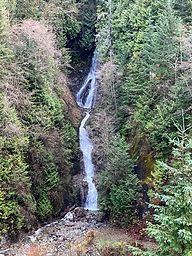
The Britannia Watershed has been home to the Britannia Mine since the late 1800s. The mine went into full copper production in 1903, and the community of Britannia Beach grew up around the mine. While it was an excellent source of revenue for its investors, the devastation wrought by the mining and refining process left Howe Sound polluted and bereft of much of the previous wildlife that lived in and around its waters. Acid rock drainage created a marine dead zone around the region of Britannia Creek where nothing could survive in the marine environment.
Ruth Simons, Executive Director of the Howe Sound Biosphere Region Initiative Society, says that much of their recent funding has been aimed at strengthening conservation in the biosphere. She says back when her group began engaging with local communities, they realized there was a need for an organization to be the repository of historical information about the recovery of Howe Sound.
"The Storymaps are a way for us to bring all the information on the changes in the landscape over time, to identify gaps in information, outstanding and new remediation work and identify areas for protection and conservation," says Simons. "The technology, combined with GIS (geographic information system) expertise and open-source data, provides us with the ability to share the stories and provide a portal to detailed information for researchers and educators and more."
Simons says the Britannia Watershed Storymap took her team of four members more than four months to complete. It is the third in a series, following storymaps of the Squamish River Estuary region and the McNab Creek Watershed. While each storymap provides the history of the region, there is also a strong emphasis upon the remediation that has taken place to counter the long-term damage resource extraction has left in each region.

If they can secure continued funding, the Society also has plans to give both the Furry Creek and Woodfibre Valley regions the storymap treatment.
Simons notes the project was undertaken with funding from Environment and Climate Change Canada and the Squamish Lillooet Regional District (SLRD), along with in-kind support from many stakeholders.
The community of Britannia Beach has grown massively in recent years and with the influx of new homes along with a new fire hall and general store, the community is more popular than ever. Visitors, Simons says, "can view the crystal clear waters in the creek that fish are now enjoying. Those that have watched this creek for decades were thrilled at the return of the fish to the lower portions of the creek."
The Howe Sound Biosphere Region Initiative Society was formed in 2017. Simons says that the elements of the remediation and recovery of this region were key features of their nomination to UNESCO. She also notes that with tourism booming in the region, and the UNESCO designation, the Squamish Lillooet Regional District (SLRD) has been open to the Society's advocacy for a sustainable community and a healthy region when it comes to planning.
Simons feels the story maps help to broaden both public and government perspectives and allow people to be more informed when making decisions for the future. She notes that understanding the time before settlers, when First Nations peoples were thriving, brings context to contemporary work on reconciliation.
"By understanding the geology and how the land we live on was formed, we can understand and care more about our biodiversity, We can understand how altering the land for extraction purposes can have great environmental and economic consequences," she says. "Hopefully, people are inspired by what can be when we take necessary steps in regulation and environmental controls and are contributing towards a better, even more sustainable future for generations ahead."
The storymaps of the Britannia Watershed and other Howe Sound regions are available to all, including anyone researching the area for work or school.
Simons says she has had a positive response from members of the SLRD, who have told her the information has been useful. And with its different focus, the Britannia storymap provides an alternative narrative from what people hear when visiting the mine museum.
Learn more about the Howe Sound Biosphere Region Initiative Society HERE, and view the Britannia Watershed storymap HERE. Donations to the society can be made HERE.

The Watershed values your opinion. Leave your thoughts below or
Like what you're reading?
For as little as $5/month, you can support local independent journalism


Wow, a veritable wealth of local information!